Day 1: Milngavie – Balmaha (20 miles)
Milngavie—Carbeth (5 miles, 8km). Total ascent: 148m, total descent: 69m, max height: 130m. Terrain: A relatively simple start to the Way on footpaths, tracks and lanes with no major climbs.
Carbeth—Drymen (7 miles, 11.2km). Total ascent: 271m, total descent: 238m, max height: 163m. Terrain: A relatively simple stage on footpaths, minor roads and made up path on dismantled railway trackbed.
Drymen—Balmaha (8 miles, 12.8km). Total ascent: 292, (via Conic Hill), total descent: 437m (via Conic Hill), max height: 310m (via Conic Hill). Terrain: Good paths or tracks most of the way. The only significant ascent being the section of the route over Conic Hill near Balmaha.
Let’s go!
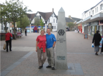
From the official start point of the walk — a granite obelisk in Douglas Street, we made our first step of many on the 95 mile route.
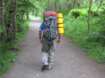
The first stage of the walk was relatively easy going. We followed the high street onto a path through a narrow ribbon of trees alongside Allander Water. Allander Park lies immediately north of Milngavie and is a mixture of woodland and open heath. The track swings northwestwards to come down to the riverside once again, and a substantial path leads the walker across the county boundary into Stirlingshire, and the environs of Mugdock Country park. Mugdock Country Park is an outdoor activity centre although you wouldn’t think this too easily. It was during our time in Mugdock Wood that we met one of the many other groups of people also attempting the walk. We must however add that we were the only ones carrying full kit as everyone else was using one of the many luggage handling companies (where they take your luggage to your next destination!). A bit of a cheat’s way of doing the walk—even though we say so ourselves!! We left Mugdock Park near Craigallian Bridge.
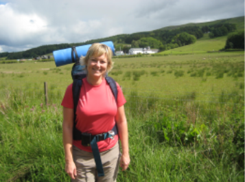
After passing Craigallian Loch on our right, we caught the first sight of Dumgoyne Hill. We then passed the large expanse of Carbeth Loch on our left and shortly afterwards met the B821 (to Strathblane). We headed towards Campsie Fells via Dumgoyach, a tree studded hill. Following the Blane Valley Railway (now abandoned) route was easy. We eventually came across the Glengoyne Distillery on the right of the path (a large white building, with a pagoda shaped roof). The distillery is open to the public and a notice on the Way indicates a path to it and extends an invitation to sample “Scotland’s unpeated malt whisky” . On this occasion we decided to pass up on the offer, besides Keeley doesn’t drink whisky so the trip would have been somewhat wasted!
Having crossed the river at Gartness, we eventually arrived at the A81. This is the point where those staying in Drymen leave the way. We were originally planning on having lunch in Drymen but it’s actually about ¼ mile walk and with still 8 miles to go, we made the decision to carry on.
After crossing the busy A811 (Balloch-Stirling road), we passed through the gate and walked about 1km before entering Garadhban Forest (part of the Queen Elizabeth Forest Park), a conifer plantation currently undergoing harvesting. The forest track continues for about 6km along a forest track. It was whilst walking along this route that we first got sight of the first climb of the walk— Conic Hill (altitude 361m, or about 1200ft). Lying just within the Highland Boundary Fault, Conic Hill can therefore be classed as the first summit of the Scottish Highlands.

The path goes along the edge of two fields before crossing the Burn of Mar (vicinity of the Highland Boundary Fault). It is at the Burn of Mar where we decided to rest our feet, fill up with water and take in some well earned refreshments. Tim decided he wanted to eat his chocolate pudding (a leftover ration from his army days). There was no convincing Keeley to go anywhere near it!
Well, it did look like mashed up baby food and no matter how hungry I might have been, I just wasn’t THAT hungry!!
After a short re-fuelling break, we made our ascent up Conic Hill. The way emerged onto open moor land and headed up the ridge to the summit. The Way follows a natural ledge just below the summit.
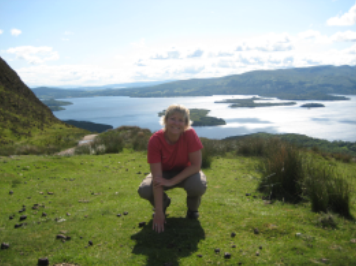
Although neither of us had the energy to go to the top (very unusual for Tim as he usually likes to get to the top of anything and everything!), the views from the path just below were just as stunning. On a clear day it is apparently possible to see Goat Fell on the Isle of Arran, 50 miles (8km) to the south west. Further round towards the south is the rounded outline of Ailsa Craig in the Clyde Estuary, one time source of granite used to make curling stones.
The Way skirted the central and southwest tops and then cut between them and Tom nan Oisgean, via a craggy little col named Bealach Aird. We followed the path around the bealach and descended through forest to the south of Tom nan Oisgean. The route then drops steeply from the bealach, through a corrie between two ridges (thank goodness for walking poles!!). We eventually came to a built up stone staircase which brought us down to more conifer forest. The forest path then lead us to the car park at Balmaha. It was only when we arrived at the car park that Tim realised that it was a car park—all the way down he thought it was some form of water! Blimey, he must have been hallucinating with the tiredness.
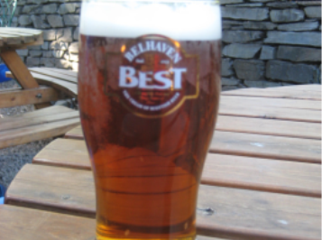
We were planning on camping the first night but after having a pizza (and a pint!) at the Oak Tree Inn, we stumbled across a sign advertising rooms for £15! The Balmaha Bunkhouse facing Loch Lomond had only been open a month and after 20 miles, was an excellent place to stay. The owners were very friendly and the private double room that we had was perfectly adequate. The bunkhouse had 2 bathrooms, a modern kitchen and a living area. As the bunkhouse had just opened, it wasn’t very busy. In fact, we were the only people there along with a younger german couple. They too were doing the West Highland Way (but more of them later).
After showering (bliss) and getting sorted, we mustered enough energy to return to the pub for tea (burgers and chips). Aside from the pub, we didn’t seem to find much in Balmaha….not that we explored too much as our feet and legs were sore and aching.
Completely full of junk food, we had an early night in preparation for Day 2.
Day 1 (Milngavie – Balmaha) click here
Day 2 (Balmaha – Inversnaid) click here
Day 3 (Inversnaid – Auchtertyre) click here
Day 4 (Auchtertyre – Rannoch Moor) click here
Day 5 (Rannoch Moor – Kinlochleven) click here
Day 6 (Kinlochleven – Fort William) click here
A relaxing 2 days click here
